

CLINICS + meetups
Flash Foxy mini fest • red river gorge • MAy 16-18, 2025
Schedule is always subject to change. All programs run rain-or-shine. No refunds.
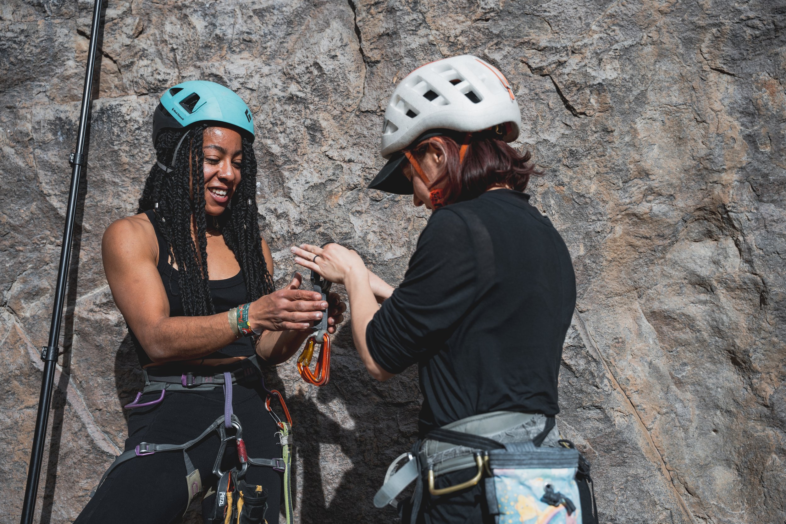
Clinics
-
All clinics are 6 hrs and have a maximum of 12 participants.
Clinics are reserved for registered festival participants. Clinic registration link will be sent via Eventbrite, early bird clinic registration will open the day before. Clinic Registration link (and waitlist link) can also be found in the festival linktree.
-
There is a $110 per day registration fee for all clinics.
Registration link will be sent directly to all festival participants via Eventbrite. Clinic registration link (and waitlist link) can also be found in the festival linktree.
Clinic registration opens April 15th! Early Bird clinic registration opens April 14th.
-
All location listings are tentative and subject to change day-of. If you have an accessibility concern related to venue locations please email events@flashfoxy.com after registering for your clinic and we will work with you to see if the clinic can be held at a venue that meets your accessibility needs. If we are unable to accommodate your needs we will gladly refund the clinic registration fee.
-
Climbing gear is provided for all clinics. There will be climbing harness, shoe and helmet demos available. If you have any gear that you would like to ask questions about/practice with at your clinic, feel free to bring it!
All clinics will be run in partnership with Bluegrass Climbing School (BGCS).
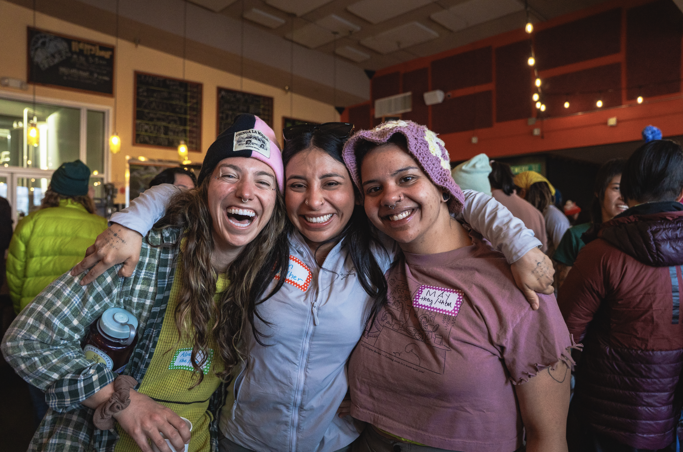
Meetups
-
Meetups are free and are INCLUDED with your festival pass, just show up! Some will be climbing, some will be other activities for climbers!
These Meetups are open only to registered festival participants. Please note schedule is always subject to change.
-
Meetups will take place on Friday after Climber Coffee at 10am and Saturday at 11am!
-
Meetups are not guided or instructional in nature. They are opportunities for participants to meet each other and find new friends to climb with. Meetup leaders will be familiar with local climbing. We encourage all participants and meetup leaders to make informed risk decisions and have conversations about risk and experience with all new climbing partners. Remember, climbing is inherently dangerous and you are responsible for your own safety.
-
Participants are responsible for providing their own gear for meetups.
-
All location listings are tentative and subject to change day-of. Locations are selected by meetup leaders. Meetup locations tend to be flexible, so please advocate for your accessibility needs!
Climbing Areas

Make sure to fill out your waivers!


-
Google Maps: Motherlode Parking Lot
Bald Rock Recreational Preserve (BRRP) is owned by the Red River Gorge Climbers’ Coalition and home to the Red’s iconic Motherlode. This area also hosts other popular areas like the Chocolate Factory and Hazel Hollow. You’ll find a host of climbs ranging from 5.6 to 5.14d here.
Approach + Trail Surface: Trails vary based on destination, ranging from short and flat to uneven. Trails between climbing areas are mixed terrain including exposed rocks, loose sand/dirt, and mud. Please use Mountain Project or a guidebook to gauge the trail to your specific destination.
Directions: From Lago Linda, turn right onto KY-52 E. Continue for 2.4mi and turn left onto HWY 498. After 1 mile turn left onto Bald Rock Fork Rd, which will be a gravel road on your left. From KY-11, turn right onto Hwy 498. After 1mi, you can take a slight right toward Hopewell Church or continue on Hwy 498, round a corner, and turn right onto Bald Rock Fork Rd (gravel road).
All cars will enter the area via a steep hill. There are three parking lots at the base of the Motherlode hill. There is a top lot on the left side before you enter the steep hill, recommended for 2WD cars. -
Google Maps: Motherlode Parking Lot
Pendergrass-Murray Recreational Preserve (Motherlode entrance) is owned by the Red River Gorge Climbers’ Coalition and home to some of the Red’s most popular areas like Drive-By, The Gallery, and Purgatory. You’ll find a host of climbs ranging from 5.6 to 5.14d here.
Approach + Trail Surface: Trails vary based on destination, ranging from short and flat to uneven. Trails between climbing areas are mixed terrain including exposed rocks, loose sand/dirt, and mud. Please use Mountain Project or a guidebook to gauge the trail to your specific destination.
Directions: From Lago Linda, turn right onto KY-52 E. Continue for 2.4mi and turn left onto HWY 498. After 1 mile turn left onto Bald Rock Fork Rd, which will be a gravel road on your left. From KY-11, turn right onto Hwy 498. After 1mi, you can take a slight right toward Hopewell Church or continue on Hwy 498, round a corner, and turn right onto Bald Rock Fork Rd (gravel road).
There are multiple parking areas depending on which crag you are going to. All cars will enter the area via a steep hill. Once at the base of hill, continue down the road to the parking lot for your crag. There is a top lot on the left side before you enter the steep hill, recommended for 2WD cars.Do not block oil machinery.
Parking lots:
Flat Holler Parking Lot Crags: Velo, Throwback, The Lumber Yard, The Getaway, The Shipyard
Sore Heel Hollow Parking Lot Crags: Curbside, The Gallery, Left Field, Volunteer Wall, The Playground, Bronaugh, The Mega Cave, North 40, Purgatory, Courtesy, Rival, Shady Grove, The Shire, What About Bob
Drive-By Parking Lot Crags: Drive-By, Chica Bonita, Bob Marley
Note: Sore Heel Parking Lot is only recommended for 4WD/AWD cars with substantial clearance. There is an access trail off of the main road to hike back to these crags. -
Google Maps: Far Side Parking Lot
Pendergrass-Murray Recreational Preserve (Coal Bank entrance) is owned by the Red River Gorge Climbers’ Coalition and home to some of the Red’s most popular areas like Darkside, Solar Collector, and Gold Coast. You’ll find a host of climbs ranging from 5.6 to 5.14d here. Gold Coast also has some great entry-level trad for you crack climbers.
Approach + Trail Surface: Trails vary based on destination, ranging from short and flat to uneven. Trails between climbing areas are mixed terrain including exposed rocks, loose sand/dirt, and mud. Please use Mountain Project or a guidebook to gauge the trail to your specific destination.
Directions: From Lago Linda, get onto KY-11 and head North toward Mountain Parkway. Continue for 5.4mi. Once you pass the Marathon gas station, prepare to turn left in about a mile onto Hwy 1036 toward Peaceful Valley Resort. This road will change from pavement to gravel. Continue on this road for approx 5mi. When you see a black tank on the left side of the road, turn right onto the next gravel road.
It is recommended to approach via Fixer Rd, not Cave Fork via Ashland Camp Rd. There is a central parking area for all crags. 4WD/AWD highly recommended for access.Do not block oil machinery.
-
Google Maps: Miller Fork Recreational Preserve
Miller Fork Recreational Preserve (MFRP) is owned by the Red River Gorge Climbers’ Coalition and home to popular areas like the Infirmary, Fruit Wall, and Camelot.
Approach + Trail Surface: Trails vary based on destination. Trails between climbing areas are mixed terrain including exposed rocks, loose sand/dirt, and mud. Please use Mountain Project or a guidebook to gauge the trail to your specific destination.
Directions: 4WD/AWD highly recommended for access. River crossing required if approaching from Beattyville and navigated via Holly Rd.
From Lago Linda, get onto KY-11 N towards Mountain Parkway. Continue for approx 5mi and turn right onto Shoemaker Rd. Continue on Shoemaker Rd for 3.5mi. You’ll pass a house with a lot of equipment in the yard, a 35mph speed limit sign, and possibly pigs (beware, they’re free roaming). Be prepared to take the middle driveway once you round the corner; the descent is steep at first.Do not block oil machinery. Please do not park on Shoemaker Rd.
-
Google Maps: Muir Valley Nature Preserve
Muir Valley Nature Preserve is operated by the Friends of Muir Valley and hosts the highest concentration of climbs in the 5.2-5.10a range. Climbing access to this area costs $15 per car.
Approach + Trail Surface: Trails vary based on destination. Trails between climbing areas are mixed terrain including exposed rocks, loose sand/dirt, and mud. The North trail includes a significantly steep wood staircase. Please use Mountain Project or a guidebook to gauge the trail to your specific destination.
Directions: From Lago Linda, get onto KY-11 and drive toward Mountain Parkway for 5.8mi. Take a slight right onto KY-715. Continue for 2.6mi then take a right onto Big Andy Ridge Rd (JCT 2016). After .8mi take a left onto Fincastle Rd.
This climbing area is access-friendly to 2WD vehicles.
-
Google Maps: Muir Valley Nature Preserve
Graining Fork Nature Preserve (Roadside) is a privately owned and operated crag. Permits are required for access and must be requested in advance. Popular routes include Roadside Attraction, Return of Chris Snyder, and Ro Shampo.
Approach + Trail Surface: Park in the gravel lot shared with Hop’s Fork Restaurant and cross the road. Follow the short trail to the cliffline.
Directions: From Lago Linda, get onto KY-11N and drive toward Mountain Parkway. Park in the lot shared with Hop’s Fork.
This climbing area is access-friendly to 2WD vehicles.
-
Google Maps: Ash Branch Climbing
Ash Branch is a newly-developed, privately-owned crag near Muir Valley. This area gets morning sun to full shade. Routes are new, so expect some choss. Helmets are recommended.
Approach + Trail Surface: From the parking area, find the green rules sign and hike downhill on the wide gravel path. Cross the creek and head uphill, turning left at the arrow. Trail reaches the cliff to the right of Humanoid. Go left for Humanoid- routes are still listed left to right.
Directions: From Lago Linda, get onto KY-11 and drive toward Mountain Parkway for 5.8mi. Take a slight right onto KY-715. Continue for 2.6mi then take a right onto Big Andy Ridge Rd (JCT 2016). After .8mi take a left onto Fincastle Rd. Look for a gravel drive on the right with a wooden sign that says ‘Ash Branch Climbing’ approx .2mi after turning onto Fincastle Rd. Descend the steep hill from there, taking a hard left at the bottom to find parking.
Do not climb tagged routes. These routes are undergoing cleaning, not complete, or not open to the public. -
Google Maps:
Nada Tunnel Access
Sky Bridge Rd AccessThe Northern RRG hosts the majority of the Red’s trad climbing, but also some classic sport. This is where you’ll also find the Red’s first classified rock climb, Caver’s Route, and the uber classic Bedtime for Bonzo 2-pitch romp. Climbing is within the Daniel Boone National Forest and managed by the US Forest Service.
Approach + Trail Surface: Trails vary based on destination. Trails between climbing areas are mixed terrain including exposed rocks, loose sand/dirt, and mud. Please use Mountain Project or a guidebook to gauge the trail to your specific destination.
Directions: There are two ways to enter the DBNF Scenic Loop which is the main access road for the majority of crags in the North. From Lago Linda, get onto KY-11 and drive toward Mountain Parkway. If you are entering via Nada Tunnel, pass under Mountain parkway and turn left onto KY-15N. After 2.2mi, turn right onto KY-77N. Note: Nada Tunnel can only accommodate cars in one direction at a time. You may have to wait as cars pass through. To enter via Skybridge Rd, take a slight right onto KY-715 as if you are going to Muir Valley. Continue for 18mi and take a right onto Sky Bridge Rd.
Parking spots are pull-offs from the main road, paved and 2WD friendly.
-
All primary festival activities (opening party, workshops, board games, panels, dinner) will be held at wheelchair accessible venues and will have accessible bathrooms. The Fireside Chat will take place adjacent to the Pavilion, in a flat grassy area.
ASL interpreters can be coordinated upon request. Please email events@flashfoxy.com to discuss your needs.
Approaches differ by climbing area. Details about approaches can be found below, or can be found on Mountain Project.
Have an accessibility concern? Reach out to events@flashfoxy.com and we’ll see how we can help!
We are always working to make the Flash Foxy Climbing Festival a more inclusive and welcoming space, please let us know what we can do to make our event more accessible for you. Unfortunately, we are not always able to arrange accommodations, but we will do our best and will provide honest answers about the our event spaces, staff capabilities and the activities that take place at our festivals. Thank you for learning and growing with us!
-
Google Maps: Lago Linda Hideaway
About the venue: All of our programming, with the exception of clinics and our stewardship projects, will take place at Lago Linda Hideaway. Workshops, demos, board games, and Sunday morning’s community conversation will take place under their big pavilion. Field games and Saturday’s Fireside Chat (Panel) will take place in the grassy open space next to the pavilion. The Shake-Out Lounge is located next to the Pavilion and is a comfortable indoor space with outlets, free WiFi, and tables. NOTE: The Shake-Out Lounge will be open to other campers at Lago Linda Hideaway during the festival.
Bathhouses are located at the front of the property near the Café and by the Bertie Branch primitive camping area.
The roads through Lago Linda are gravel, and these serve as major pathways to and from. The campground where we will be staging is the flattest location and is a combination of grass and gravel. The terrain still undulates but not nearly as much as the other surroundings. Cars can access almost any single nook and corner of the camp ground.
Directions: Take the Exit 33 toward Slade. Turn right onto KY-11 and continue for 14 miles. Turn right into Hwy 498, continue for 2.5 miles. Turn right onto KY-52 W and continue for 2.4 miles. Turn left onto KY-399 S. Follow signs to Lago Linda. There is a large parking lot with marked accessible parking spaces available.